

With trails along with beautiful islands, stunning beaches, and Avatar blue waterfalls, it’s not easy to pick the best hiking trails in California.
Are you looking forward to stepping out into the wilderness? Do you want to take a break from the busy city life? Then hiking trails in California are your go-to place.
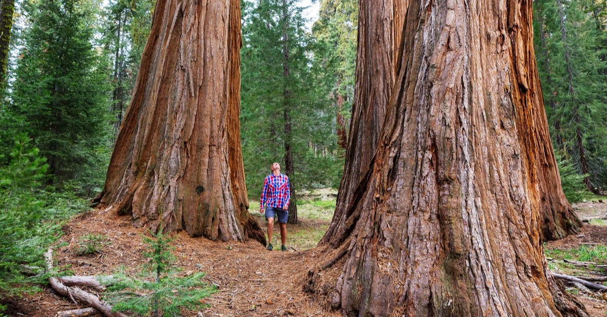
From Yosemite National Park, which has the longest waterfall in North America, to trails along the tallest trees in the world found in the Redwood National and State Parks and the epic hike to the summit of Mount Whitney, there are several best hiking trails in California.
California is home to trails along a dramatic coastline, cascading waterfalls, sky-high granite mountains, and the tallest trees. But that's not it. The state also offers trails that take you to crystalline blue lakes and mesmerizing desert oases. Given this overwhelming variety, choosing the best hiking trails in California is never easy.
But we have done it for you. As a native Californian and an avid hiker, we have compiled together a guide on the best hiking trails in California that include various lengths, difficulty levels, and landscapes. So no matter your fitness level or your hiking experience, you will find the best hike for yourself on this list. So let's get started.
Best Hiking Trails in California
John Muir Trail
Trail Length:211 miles – takes an average of 3-4 weeks to complete
Difficulty: Challenging route
Best Time of the Year to Visit: July – September
When it comes to hiking in California, one of the longest and perhaps the most rewarding hiking trails is the John Muir Trail (JMT) which stretches for 211 miles from Yosemite to Sequoia country. The JMT trail ends at the highest peak in the contiguous United States, Mount Whitney, which has an elevation of 14505 feet.
The trail is named after the naturalist/author John Muir, who fell in love with the Sierras and spent much of his life trying to safeguard the wilderness among this mountain range. If you are on a road trip to California and want to get off the mundane path, this trail offers you the best way to explore the most popular national parks and the wilderness areas alongside the most serene and beautiful Sierra Nevada mountains.
The trail starts in the Yosemite National Park and continues through the Sequoia National Park and King’s Canyon National Park until you reach Mount Whitney's summit, which is a tough and rewarding climb in itself.
While most people cover sections of the trail and opt for a few hours of hike, completing the trail from start to finish can take anywhere between three to four weeks. The best time to hike on this trail is between July and September, but it also depends on the snowfall.
The complete JMT hike is a serious business and requires extensive planning because you will only find very few resupply points which are far away from each other, so you need to pre-organize your logistics. Moreover, hiking the complete trail requires a permit and a 6-month reservation, making it an extremely competitive endeavor. While it is a challenging hike, with proper planning and adequate logistics, the complete JMT hike makes one of the best long-distance hiking trails in the world.
Yosemite Falls Trail
Trail Length:9.6 miles – takes an average of 5-6 hours to complete
Difficulty: Challenging route
Best Time of the Year to Visit: Late spring, Summer, and Fall
If you decide to visit the Yosemite National Park, then you need to head out to the Yosemite falls trail that leads you up to the close-up views of Yosemite's most spectacular waterfall, which also makes North America's tallest waterfall.
The Yosemite falls trail includes two parts. The first part of the trail is a mile-long, moderate hike that takes you to Columbia Rock. The hike ascends 1,000 feet, and you can view the Yosemite valley and the Half Dome in the distance. If you do not wish to continue to the second part of the trail, you can complete the 2-mile-long round trip from this point in 2-3 hours.
But if you want to continue on the second part of the trail, it makes a more challenging hike as it includes an elevation of 2,700 feet up a strenuous and rugged terrain.
If you start your hike from Columbia Rock, the round trip on the second part of the trail will take somewhere between six to eight hours. The hike completes as you reach the Glacier Point visitor’s center, which offers one of the best viewpoints of the valley. The trail is exciting as it takes you close to North America's tallest waterfall, and while climbing this trail, hikers often feel droplets from the waterfalls. You can enjoy the spectacular view from this point before you descend.
With both sections combined, the Yosemite Falls Trail is around nine and a half-mile round-trip hike, with the first section being moderately challenging, followed by a difficult trek in the second section.
The best time of the year to hike on this trail is during spring when the waterfalls are flowing heavily. By August, there is a decrease in water levels, making the falls a little less impressive. If you plan to hike during the summers, make sure you start your hike early during the day as the trail gets very hot by noon. Moreover, you need to ensure plenty of drinking water, as bottled water is not available on the trail. Lastly, watch out for any loose sand or rocky walkways as they can be slippery, and always stay on the path. The trail is not safe for a hike during winter, especially when it is snowy.
Boy Scout Tree Trail
Trail Length:5.5 miles – takes an average of 3-4 hours to complete
Difficulty: Easy to Moderately Challenging route
Best Time of the Year to Visit: May to September
If you live in Northern California and need a break from the hustle-bustle of urban life, hiking on the Boy Scout Tree Trail in Jedediah Smith Redwoods State Park is a great choice for you. The Jedediah Smith Redwoods State Park is one of the Redwood National and State Parks that gives you an amazing feeling of being away from the happening city life.
The moderate trail is a 5.6 miles round trip and is definitely among the best hikes in the Redwood National and State Parks. The trail is typically an easy hike, with the exception of a few areas that offer steep elevations. And while it takes a few hours to complete the hike, it is a good idea to allow yourself half a day on the trail so you can enjoy your time admiring the amazing canopies of the giant trees.
About 2.5 miles from the start of the trail, you reach a 2,000-year-old double redwood tree which was named the Boy Scout Tree as a Boy Scout troop leader discovered it. The trail ends at the mesmerizing Fern Falls before hikers can start on their return journey.
While the weather is pleasant for hiking throughout the year, the months before May and September are the best to hike on this trail as the trail can be slippery during the rainy season.
Fern Canyon, Prairie Creek State Park
Trail Length:2 miles round trip, which takes around 1 hour to complete.
Difficulty: Easy route
Best Time of the Year to Visit: All year round
If you are looking for a remarkable hiking trail that offers incredible views and amazing plant diversity while allowing you to hike with young children, then the Fern Canyon trail in Prairie Creek Redwoods State Park in Humboldt County is for you. And in case you don’t know, film director Steven Spielberg filmed scenes for Jurassic Park 2: The Lost World here thanks to the biodiversity and splendid views that this trail has to offer.
The Fern Canyon makes the shortest hike on the list; that is only 1.1 miles long, and you will only need an hour to complete the two-mile round trip. The trail’s starting point to Fern Canyon is about 1/4 mile from the canyon and makes an easy hike. You can also merge this hike with the moderately challenging James Irvine Trail, which makes a five-mile trip starting from the Prairie Creek Redwoods State visitor center.
For those who are just hiking in the Fern Canyon, you can hike into the canyon and return back in around an hour or two, and the small hike will reward you with amazing views and breathtaking flora along the walls.
While the Fern Canyon makes a year-round hike, it is best to avoid considering hiking here during the wet winter months.
Murray Canyon Trail
Trail Length:3.7 miles which takes 2-3 hours
Difficulty: Easy to Moderately challenging route
Best Time of the Year to Visit: October through March
While you have the Boy Scout Tree Trail in the North, Southern California also has something great to offer you, and that is the Murray Canyon Trail which is one of the best hiking trails in Southern California. The hidden oasis in the Agua Caliente Indian Reservation at the bottom of the San Jacinto Mountains seems like an illusion that has come to life.
The easy to the moderately challenging trail is flat in the beginning, and you can find yellow flowers, small rocks, and large lizards along the path. But very soon, you will get to the creek that is formed by melting snow which is surrounded by splendid fan palms. The path continues through a sandstone canyon formed by erosion, eventually forming a spectacular pool fed by rainfall and is the place where you will find mule deer and bighorn sheep drink water.
The easy to moderately challenging hike takes a few hours, and most people can expect to return to the starting point in around three hours. The best time of the year to visit this trail is between October and May, when you will likely find water in the oasis.
Lost Palms Oasis and 49 Palms Trails
Trail Length: Lost Palm Oasis – 7.2 miles round trip, which takes between 3 and 4 hours; 49 Palms Oasis – 3-mile round trip, which takes around 1 hour and 30 minutes to complete.
Difficulty: Moderately challenging route
Best Time of the Year to Visit: October through April
For adventurers who are looking forward to hiking on trails that are different and more challenging than the trails in the woods, Joshua National Park, located in the tough and barren Mojave Desert, offers the best hiking trail. The National Park offers several interesting trails that travel through palm oases, including the Lost Palms Oasis Trail and the 49 Palms Trail.
The Lost Palms Oasis Trail is a moderately challenging route that is around 7.2-mile long. The round trip can take anywhere between 3 and 4 hours and takes you to a canyon filled with palm trees and refreshing pools of water. The oasis offers a mesmerizing view, and the trail ends at the Cottonwood Campground, which features a picnic area and drinking water.
The Joshua National Park offers the other amazing trail, the 49 Palms Oasis Trail. The trail is moderately challenging if you are a beginner-level hiker as it involves an elevation gain of 300 feet and is a three-mile round-trip trail. The end of the trail rewards you with pools of freshwater that are shaded with palms. The ascent on this trail may be challenging, especially if you choose to hike during the warmer months of the year, which is why we recommend hiking on the Joshua National Park trails from October to April.
Pomo Canyon to Shell Beach Trail
Trail Length: 7.2 miles round trip, which takes an average of 3 hours and 30 minutes.
Difficulty: Moderately challenging route
Best Time of the Year to Visit: April through October
From mountains to deserts and beaches, California has too much to offer, and surprisingly there are hiking trails all across. For hikers who love to hike by the breathtaking coastal scenery in California, the Pomo Canyon to Shell Beach Trail found in Sonoma County makes the best place to be.
The trail is a moderately challenging 7.2 miles round trip and a 3.5-mile one-way hike that takes you through various landscapes. As you start the hike, you get through the lush redwood forest, which then follows the stunning views of the Pacific Ocean. You can find several colorful seasonal wildflowers along the picturesque creeks, and as you move towards the end of the trail, it joins up a road that comes down to Highway 1. The short walk from the highway takes you to the sandy shoreline of Shell Beach.
You can end your hike by the Shell Beach parking lot, which can also be a starting point for hikers who wish to do a reverse hike that starts by the beach and ends at the Pomo Canyon.
Trans-Catalina Trail, Catalina Island
Trail Length: 38.5 miles hike, which takes between 3 and 5 days
Difficulty: Challenging route
Best Time of the Year to Visit: Spring, Winter, and Fall
If you want to take your hiking experience to the next level, don't forget to hike on the Trans-Catalina Trail. It is probably one of the best hiking trails in Southern California. Catalina Island is about 22 miles south of the mainland and is an easily accessible place if you are traveling to Los Angeles.
The hike is considered a challenging route, so it is definitely not for beginner hikers as it is also one of the longer hiking trails in California. The trail makes a popular spot for avid hikers, but you can enjoy some quiet time in nature on an island which is often a once-in-a-lifetime experience.
The hiking trail can be a challenge, particularly during summer, as the weather gets too hot and humid. Therefore, it is best to hike in spring or fall and even in winter when it is most likely to rain, but you can still hike and enjoy the serenity on the island.
McWay Waterfall Trail
Trail Length: 0.6 miles round trip; that takes around 30 minutes to complete the hike.
Difficulty: Easy
Best Time of the Year to Visit: Winter and Early Spring
The McWay Waterfall Trail makes another exciting hike by the coastline. Starting from the Julia Pfeiffer Burns State Park stretches along the mountainous Big Sur coastline, this trail ends at a waterfall that drops off dramatically into the Pacific Ocean.
And the best part about this trail is that it is a relatively short trail (0.6 miles round trip trail) which takes only a few minutes to complete but offers you a stunning view of the 80-foot McWay Waterfall, which drops from the cliff onto the sandy beach. While it takes only a few minutes to complete the hike, hikers tend to spend more time admiring the stunning waterfall and ocean views than the actual hike.
As you choose to hike on this trail, know that hiking down to the beach can be extremely dangerous and strictly prohibited. Moreover, the best time of the year to hike on this trail is during winter and early spring, when there is enough water in the waterfall.
Solstice Canyon Trail in Malibu
Trail Length: Two-mile round trip hike, which takes around 2 hours.
Difficulty: Moderately Challenging route.
Best Time of the Year to Visit: Spring or after rainfall.
One of the other hiking trails near the coast that is worth mentioning as the best hiking trails in California is the Solstice Canyon Trail in Malibu. The Solstice Canyon Trail makes an exceptional place of serene beauty. The trail is a part of the Santa Monica Mountains National Recreation Area, which was a site of importance for the native Chumash people.
The relatively short hike (a two-mile round trip) starts at the parking lot and turns alongside a creek, through coastal shrubs and oak groves. The exciting features of the trail include mesmerizing views of the mountains and the dramatic canyons, along with a view of the deep blue Pacific Ocean.
Since the trail is near the Malibu beaches, it gets crowded over the weekends, so plan a weekday trip if you are looking forward to a peaceful escape from the bustling urban life. It is best to plan your hiking trips to this trail in Spring or after rainfall.
Clear Creek Route to Mount Shasta
Trail Length:12.4 miles which takes approximately 10 hours to complete
Difficulty: Challenging route.
Best Time of the Year to Visit: Spring and summer
So we have covered trails by the coastline, along the desert, in the mountains, and even on an island. So what is missing that California doesn't have to offer? Maybe a volcano. But don't worry. California has it all.
Located in Northern California, Mount Shasta is one of the highest volcanoes, and the clear creek route is a non-technical and one of the prettiest routes to Mount Shasta. As you take this trail, be prepared for a long and challenging hike that gains 7,900 feet; while Clear Creek Route is a non-technical route to Mount Shasta, it is still dangerous and is not for beginner hikers because you still need some experience with technical hiking before you can hike on this trail.
Before you can start the trek, you have to register at the Mt Shasta ranger station and get your permit. Some hikers choose to make a long day hike, while others may opt to stay for the excellent camping area. But once you reach the summit, know that you are on top of a dormant volcano! What else can you ask for?
About THE AUTHOR

Peter Brooks
I’m a hiker, backpacker, and general outdoor enthusiast. I started hiking out of college while working for the National Forest Service, and have been hiking ever since. I’ve been solo hiking and leading hiking groups for two decades and have completed hundreds of small hikes and some majorones such as the Appalachian Train and the Pacific Crest Trail, and hiked on four continents. I’d love to share some of my insight with you.
Read More About Peter Brooks


