

Modern apps have solved one of the most common issues faced by new hikers, making maneuvering a trail ten times easier. But hikers still wonder, what is the best hiking app?
There are trailing and hiking apps available on the market today, and choosing the right one that best fits your requirements can elevate your hiking experience to a whole new level.
According to healthline.com, with a 5-star rating on the apple store and a 4.5-star rating on the Google play store, Alltrails is the most frequently used and the highest-rated app by hikers all across the globe.
However, hiking is an entirely personal experience, and it's necessary to remember that an app that works great for one hiker might not necessarily be that helpful to another. Testing multiple forums and seeing what they have to offer is vital to figuring out which app works best for you.
Listed below are a few apps that we've selected based on user reviews, rating, quality, and overall reliability. Their unique features can help you get an insight into the most popular hiking trails in your area, read other hikers' active experiences, and plan your next trip accordingly.
Are Apps Useful when Hiking?
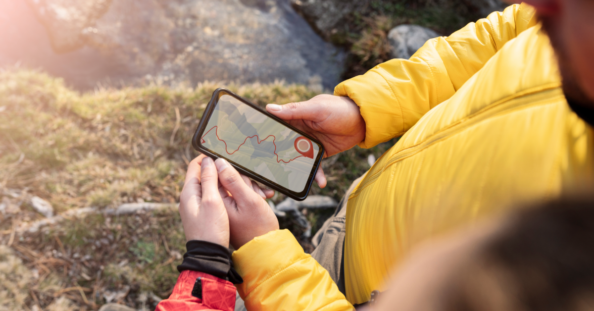
Hiking is a task that requires both physical and mental attention. Even expert hikers agree that no matter how much you plan, there are bound to be some unpredictable ups and downs on your journey. But it is these challenges that make a hike so invigorating. One of the easiest and simplest ways to remain on the trail and not get lost in using a hiking app. Hiking apps use your phone's inbuilt GPS to help you navigate through the most complex of trails.
According to smokymountains.com, wandering off the path is the number one reason hikers travel off-track and go missing. Paper maps, although helpful, can only offer so much help. They show multiple routes and trails, which can be difficult to interpret during the dark and extreme weather conditions. However, a GPS shows you a calculated way from your current location to your destination. They track your location on topographic hiking maps in real time, showing you exactly where you are and where you must go. Hikers can also share their location with their loved ones to keep them in the loop and ensure they always find their way back to safety.
Best Apps for Hiking
Thorough planning before hitting the trails is vital for a successful and seamless hike. Nowadays, modern apps have made the process of choosing a trail, planning a route, and prepping supplies accordingly much easier. Here are a few of the world's most renowned and highly rated hiking apps.

1. AllTrails
With over 50,000 trails worldwide, Alltrails is an app that most avid hikers swear by. It is an app designed specifically to keep in mind the needs of outdoor enthusiasts. From hiking and running to backpacking and cycling, Alltrails can provide details and guidelines for any nature-bound activity. The app was founded in 2010 by Russell Cook, who wanted to create a guide geared toward outdoor recreation. At present, this platform has over 10 million users making it one of the top hiking apps worldwide.
Alltrails offer an assortment of features intended to help hikers find detailed information on hiking routes, track their activity and movement in real-time, and stay safe from the uncertainties out in the wild. While being a resourceful guide and tracker, Alltrails also provides you a platform to connect with hikers worldwide and become a part of the outdoor junkie's community. This community-based platform also enables users to share routes, provide feedback, and share their experiences with fellow hikers.
This app is available for iOS and Android, offering its users two subscription options; a basic membership that is entirely free of cost and a pro membership priced at $29.99 per year, which is ideal for regular backpackers. Alltrails also offers a free 7-day trial period, allowing users to test out the pro features before committing fully to the membership.
Free Subscription
The Alltrails free subscription enables users to browse for trails using a name, city, or park, or view all the trails near their current location. The courses are categorized based on activity, difficulty level, length, suitability, and the type of routes you want to explore. Want to bring your dog along? No problem. The app can also filter routes convenient for pets, and kids, and highlights the ones that are wheelchair-friendly.
Hikers can also add custom maps and new routes that they have discovered to guide other users around those trails. The app can also be used as a personal adventure diary to track and record your journeys. You can add notes about details related to your experience and the trail conditions, save your stats such as speed, elevation, and distance covered, review the route, and add photos from the trip to solidify your memories. These notes can be shared with other users on the app and friends and family.
Pro Subscription
The Alltrails Pro membership offers everything included in the free subscription and more. For a low annual cost of $29.99, the pro subscription allows users to download maps and access them offline. So, even if you're traveling to an area with no service, you can rely on AllTrails to guide you through. The best part of the pro version is the lifeline feature which allows your loved ones to track your whereabouts in real-time. The system also sends out an alert notification as soon as you go off route. The features available on the pro version don't just help you navigate the trail but give access to map overlays - displaying the current and expected weather conditions, air quality, pollution, etc.
How to Use Alltrails?
Since the app is packed with multiple features, it may take a while to get accustomed it its usage. Start by downloading the app on your phone and registering by entering your zip code and other necessary details to set up your hiking profile.
Once you have logged in, you can see all trails and hikes within your area and curated trails created by other users. When you select your path, the app will provide you with an overview of the hike, including the terrain's difficulty, length of the hike, route type, recommendations from other hikers who have traveled this trail, pet-friendly status, and a detailed map with directions.
2. PeakFinder
From Mount Everest to the little hill around the corner, PeakFinder has a database with over 950,000 peaks and is perfect for hikers who want to enhance their mountaineering skills. The best part? This app is free; it functions offline and is available all across the globe. Designed and managed by Fabio Soldati, this app is updated frequently and uses a secure enterprise-grade environment to ensure user privacy. It doesn't hinder any applications on your phone and safeguards user data preventing sharing across applications. With millions of downloads every day, PeakFinder is breaking records worldwide.
PeakFinder is the perfect addition to a mountain buff's smartphone. This app provides a real-time local rendering of the user's surrounding landscape. It creates a digital view of the local range and enables users to pick out less prominent and more distant peaks. It displays the names of all mountains and peaks with a 360° panoramic display from an arbitrary viewpoint of your choice. PeakFinder uses an elevation model integrated into the app and a detailed database with a peak directory.
The app is relatively easy to use and very well-designed. It uses your smartphone's GPS, accelerometer, and compass to pinpoint your exact location and create an exact view of your digital landscape. With a single tap of your finger, you can view all peaks' names, details, and routes within a 200 to 300-mile radius. All you need to do is open up the peak directory, type in the view you want to see through nearby peak research, Google maps, or directly enter the coordinates. The app then displays a smooth scrolling panoramic view and a set of digital binoculars enabling you to zoom in on different peaks for a clear view. PeakFinder's database has detailed information regarding each peak's name, latitude, longitude, current distance, and directions from your location. The small hiker icon on the top allows mountain enthusiasts to view the panoramic perspective from the top of a new peal every time.
Features of PeakFinder
- Current location – a GPS button on the bottom right of the app enables the user to see a digital 360° panoramic mountain view from their current location
- Camera mode – allow users to overlay the image from their camera with a panorama drawing
- Snapshot – using the shutter button, you can take high-resolution photos of your view, which can be exported and shared with friends and family
- Editor – once you take a snapshot of a picture, a photo's mini view will appear on your screen. If you press on the photo, the app will allow you to edit and export photos with coordinates and mountain names. You can fine-tune your snapshot and even add images from other sources.
- Calibrate Compass – There is a small icon in the shape of a compass present below. It can be used to calibrate and arrange the compass if the panoramic view is shuddering or not pointing in the right direction.
- Compass Correction – If the panoramic view is still not aligned properly, you can manually correct its alignment. All you must do is drag your panorama display to the desired direction.
- Activate and Deactivate Compass – Holding your device upright will automatically align the panorama with the direction of the compass. Holding your device flat allows you to adjust the panorama by using touch gestures manually.
- Telescope – tapping on the center of the display activates the telescopic feature enabling mountaineers to detect less prominent and unknown peaks within the range.
- Fly up – arrows located on the corners of the display enable users can see the range from a bird's point of view. They allow you to fly up and down vertically to view what is hidden behind the mountain range
- Sliders – this feature can be used to correct the compass direction, alter visibility range, and monitor the date and time of the solar and lunar orbits. You'll find the slider option on the bottom left corner of your screen
- Marks – bookmarks can be used to flag your favorite mountains or ranges you've already visited or intend to hike in the future. You can also mark other locations like your home. To view it from the mountain top's perspective
- Viewpoint selection – a highly innovative feature that helps users discover any mountain range from any random location in the world. This option can be found in the menu
- Visible peaks – The app lists all mountain ranges and peaks visible from your current location using this feature. It also shows you the location of the mountain and the easiest and most direct route toward it
It is safe to say that if you are a hiker interested in adventuring mountains and peaks, there is no better app for you than PeakFinder. This app is exceptionally detailed and includes every possible feature that a mountaineer could need to plan a successful trip.
3. Gaia GPS
Founded by Anna and Andrew Johnson back in 2009, Gaia GPS is one of the most loved mappings and mobile navigation applications. The app is designed keeping in mind the need of hikers who find the challenge of traveling on rough terrains invigorating. To ensure that the user is equipped with as much relevant information as possible, Gaia provides over 100 different maps according to the type, activity, and area you would be adventuring. The app is available for both iOS and Android users. It is compatible with multiple apple devices but is only available for mobiles and tablets in androids.
Attractive Features of Gaia GPS
Easy Navigation - On the app, you can either enter manual coordinates to find a route for your destination or directly search for existing waypoints and locations. Gaia also offers a turn-by-turn navigation system and can be connected with iOs devices like the apple watch or apple car play for easy and foolproof navigation.
Save Locations - The app allows users to search for individual destinations, waypoints, trails, and roads, as well as tracks discovered by fellow hikers, and save them. Once you've saved a route that you think deserves a future visit, you can access it from your saved items.
Offline Maps - One of the desired features of the Gaia app is the offline availability of maps. Pro hikers know that their journey can be unpredictable. You never know when you could reach a location with no mobile coverage. However, with Gaia, you can easily download a section or sections of a map that can be accessed without data usage.
Reliability - Gaia GPS considers the safety of users their utmost priority. They intend to be extremely thorough with their research on information regarding the trails and destinations mentioned on their app. All information is checked and verified to ensure that hikers can embark on their journey fully prepared and free of doubts.
Crowdsourcing - The app allows fellow hikers to connect and create a strong community of outdoor enthusiasts. Users can contribute more information regarding the tracks and details of their experiences to make the hike better for others. Gaia GPS has over 2 million public overlay maps added to their database that can be accessed on Gaia TOPO and USGS Quad maps.
Customization – A unique feature offered by Gaia is that the app allows users to customize their trails and create their routes and waypoints to make the trip more straightforward. The feature further allows you to save the routes to go back to explore them at any time. If you find your map crowded with too many markings, you can temporarily hide the saved items and declutter your map to only include the tags you want on your journey.
Effortless Off-Roading - Many hikers don't prefer following conventional routes and find the challenge of going off-terrain and traveling on rough paths quite exciting. Gaia is perfect for such unconventional backpackers as it allows you to view your activity and motion in real-time. This makes it easier and safer to travel down less-known trails and discover new locations. Gaia has often partnered with well-known organizations like the United States Forest Service to ensure users have the most accurate and reliable information regarding their trip.
Multiple Maps - Another highly desired feature on the Gaia app is that all maps are categorized and filtered according to type, area, and activity. Under the type tab, users can access topographic, satellite, road, nautical, aviation, historic, Nat Geo, and weather maps. The activity tab shows you the map according to the type of trip you have planned, including off-roading, hiking, camping, backpacking, backcountry skiing, and other sports. Finally, the area or location tab allows users to access maps worldwide. Gaia database includes maps with detailed trail guides from the USA, Europe, Canada, New Zealand, Australia, Mexico, and Asia. Having multiple maps at the tip of your finger isn't a feature that most apps will provide. Each map provides a different outlook and details that can help a hiker unmask the track, destination, or waypoint they are looking for.
Types of Memberships
Gaia GPS offers three different subscriptions to its users. They have a free subscription for casual day hikers, a premium subscription priced at $39.99 per year designed for off-grid adventurers, and the premium subscription with outside plus costing $47.88 per year for the avid everyday travelers.
Free Subscription
- Offers access to only a limited number of maps with basic routes.
- Maps can only be accessed while the user is online.
Premium
- Offers access to the complete Gaia GPS map catalog, containing Nat Geo trails illustrated, high-resolution satellite imagery, USFS, and real-time weather maps.
- Maps can be downloaded and accessed while users are offline and have no data coverage
Premium with Outside
- Offers all perks of the premium subscription and more.
- Unrestricted access to Gaia GPS, downloadable premium maps with unlimited layering.
- Users receive two annual print magazines of their choice.
- Provides members with digital content from exclusive publications like Outside, backpacker, SKI, climbing, and trail runner.
- Beginner hikers can receive detailed online courses on using a GPS, basic map and compass skills, survival tips, essentials to pack and intro to backcountry skiing, etc.
- Stream unlimited videos and shows from OutsideTV and Warren Miller.
The Bottom Line
There are countless hiking and trailing apps available on the app store today, with multiple features catering to the unique needs of each hiker. Trying out multiple platforms and utilizing their prospects is the simplest way to determine which app works best for you. Your hiking app is like your adventuring companion, a buddy that you can take along with you on all your future journeys. Although it may take a while to find the right one, the wait is definitely worthwhile.
About THE AUTHOR

Peter Brooks
I’m a hiker, backpacker, and general outdoor enthusiast. I started hiking out of college while working for the National Forest Service, and have been hiking ever since. I’ve been solo hiking and leading hiking groups for two decades and have completed hundreds of small hikes and some majorones such as the Appalachian Train and the Pacific Crest Trail, and hiked on four continents. I’d love to share some of my insight with you.
Read More About Peter Brooks


